The State Flew the Kuskokwim. An AI Prospector Arrived.
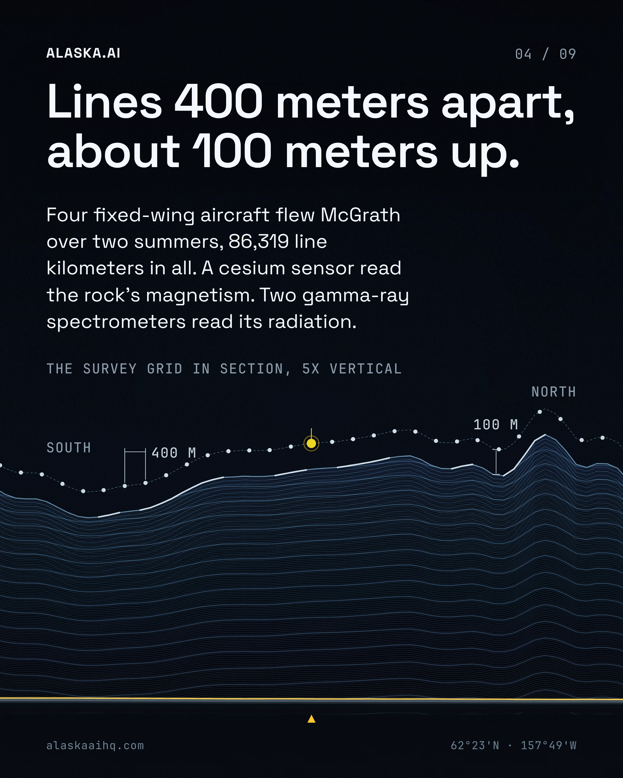
On June 23rd, 2024, four fixed-wing aircraft began flying the Kuskokwim for the state's McGrath survey.
The deck
SWIPE, SCROLL OR CLICK A SLIDE TO GO FULLSCREEN · 9 SLIDES



The story
Lines ran 400 meters apart and about 100 meters up.
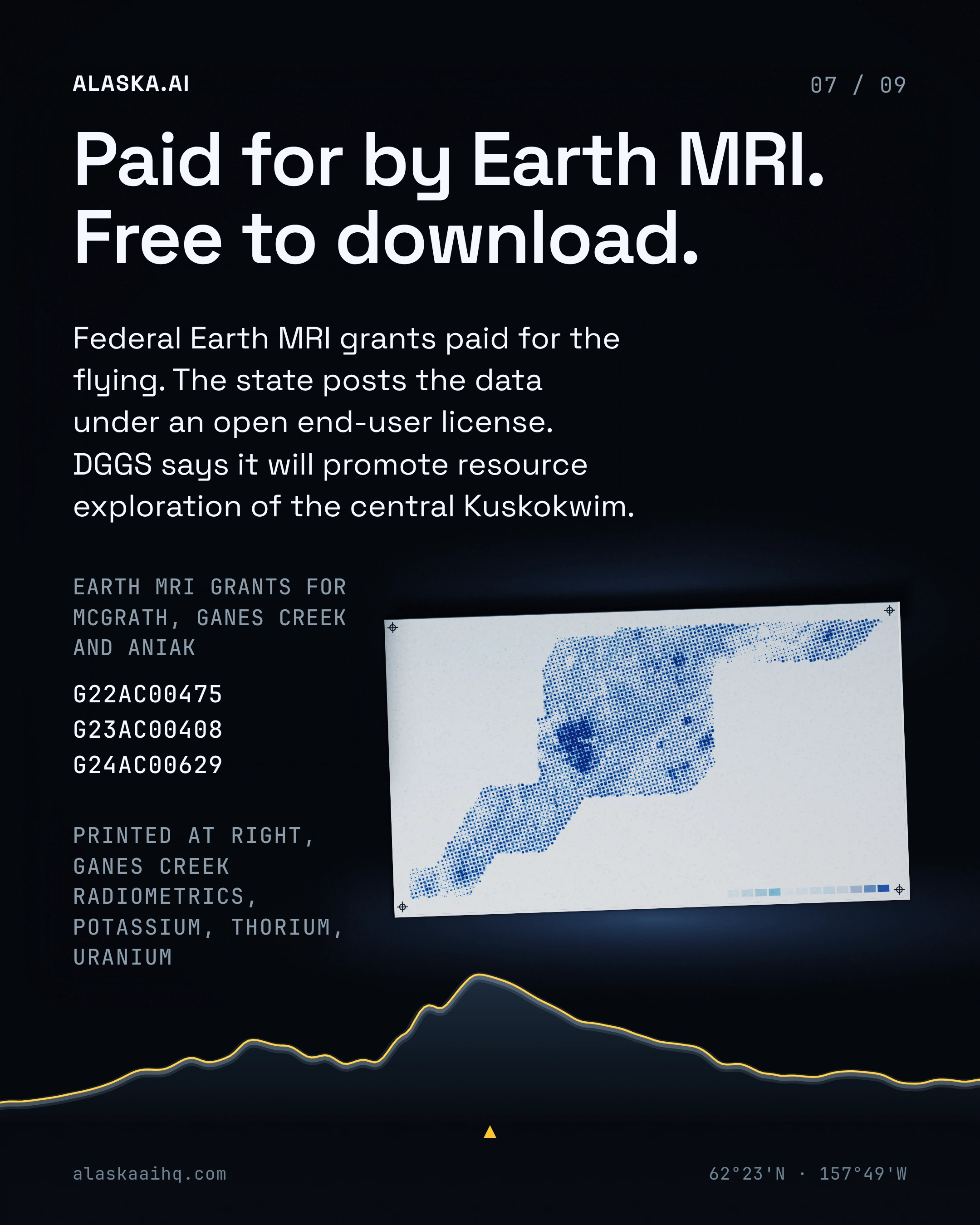
Federal Earth MRI grants paid for McGrath and its data is a free download. Four more state surveys came out this year.
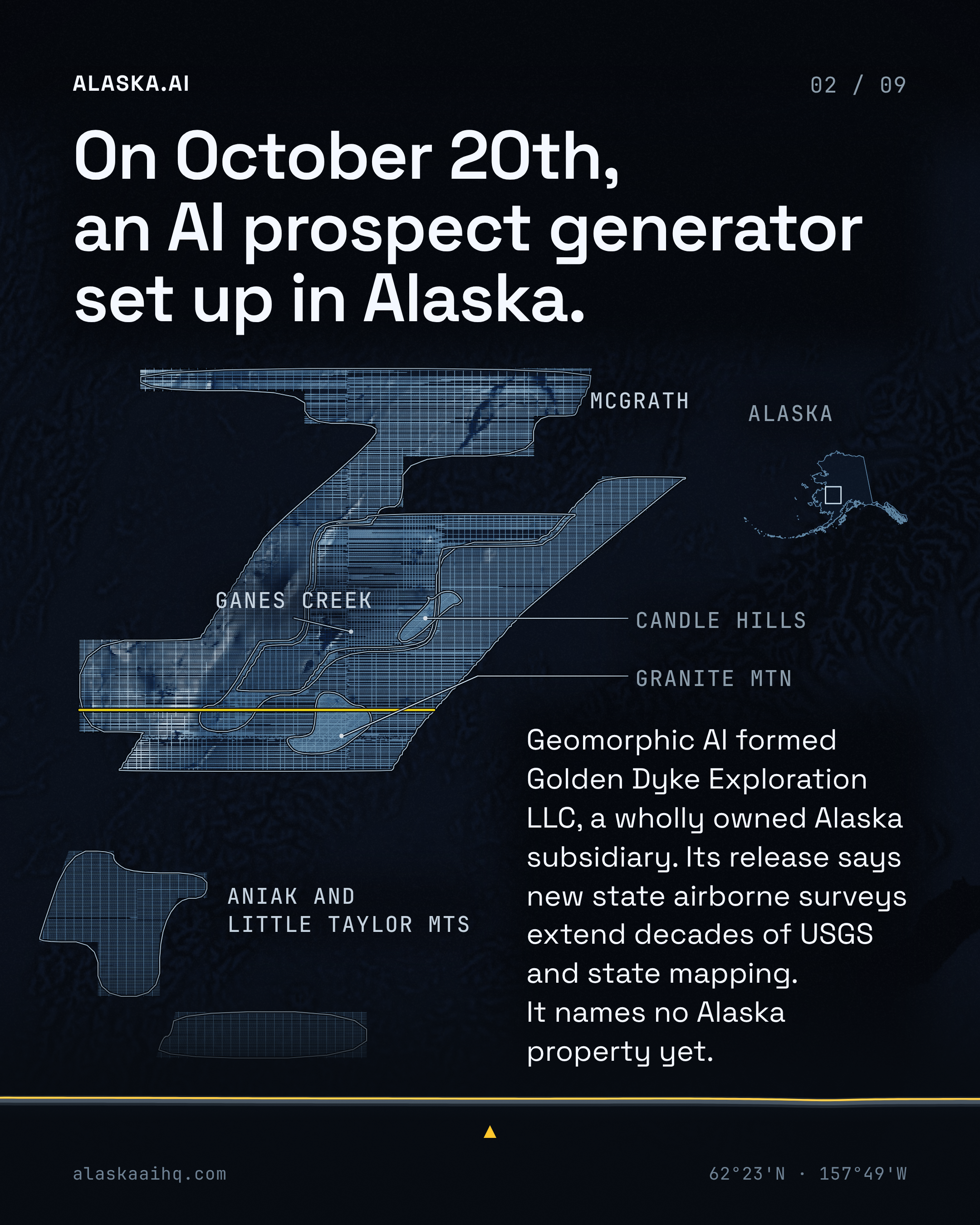
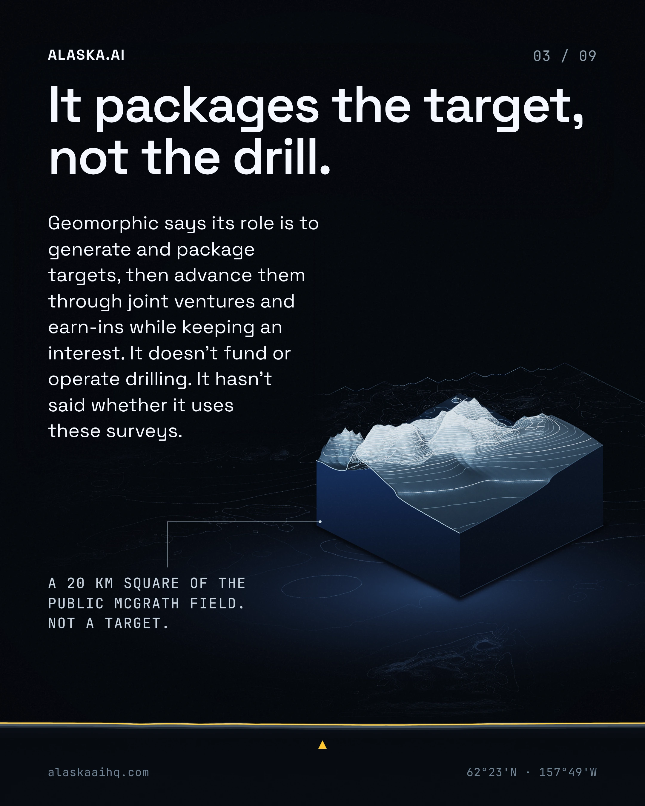
On October 20th Geomorphic AI formed Golden Dyke Exploration in Alaska. Geomorphic calls itself an AI-driven minerals prospect generator that packages targets and keeps an interest. It hasn't said whether it uses these surveys.
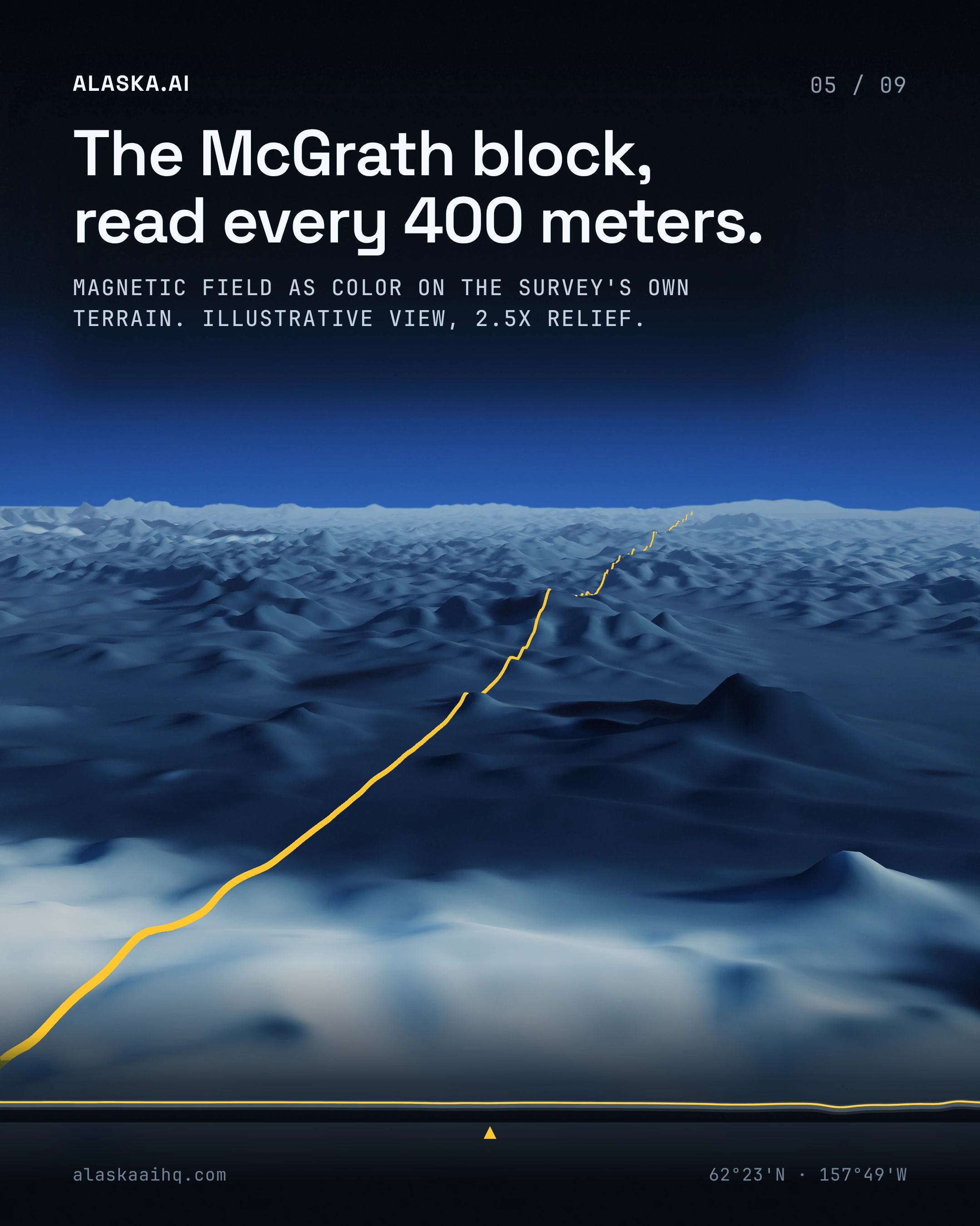
One real McGrath flight line's magnetic profile, a map and a card of five state surveys, the Ganes Creek radiometrics printed with three grant numbers, and an empty pocket for a first Alaska property, none named yet.
The state says the data will promote resource exploration. Does packaging targets for others to drill count as that exploration?
What we verified
82 CLAIMS, EACH RE-FETCHED FROM ITS SOURCE BEFORE THIS DECK SHIPPED
Geomorphic AI announced two wholly owned subsidiaries, Masi Resources S.A.C. in Peru and Golden Dyke Exploration LLC in Alaska.
Geomorphic AI dated its Alaska and Peru subsidiary announcement October 20th from Portland, Oregon.
Geomorphic AI describes itself as an AI-driven minerals prospect generator.
Geomorphic AI says it advances projects through joint ventures, earn-in agreements and other partnerships while retaining a continuing interest.
Geomorphic AI says its role is to generate and package targets and not to fund or operate drilling itself.
Geomorphic AI has not named any Alaska properties and says it expects to announce its first projects soon.
Geomorphic AI Chief Executive Officer Mark Sumner said "Peru and Alaska are two of the most prospective places in the world to explore for copper and gold, and we now have our own company in each."
Geomorphic AI's release says decades of USGS and State geochemistry and mapping in Alaska are being extended by new State airborne geophysical surveys.
Geomorphic AI announced a Kazakhstan subsidiary, Geomorphic AI Kazakhstan Ltd., on October 15th.
Geomorphic AI says it holds more than 650 Kazakh source documents totaling more than 50,000 pages.
The DGGS Ganes Creek airborne survey covers 8,197 square kilometers, about 3,165 square miles.
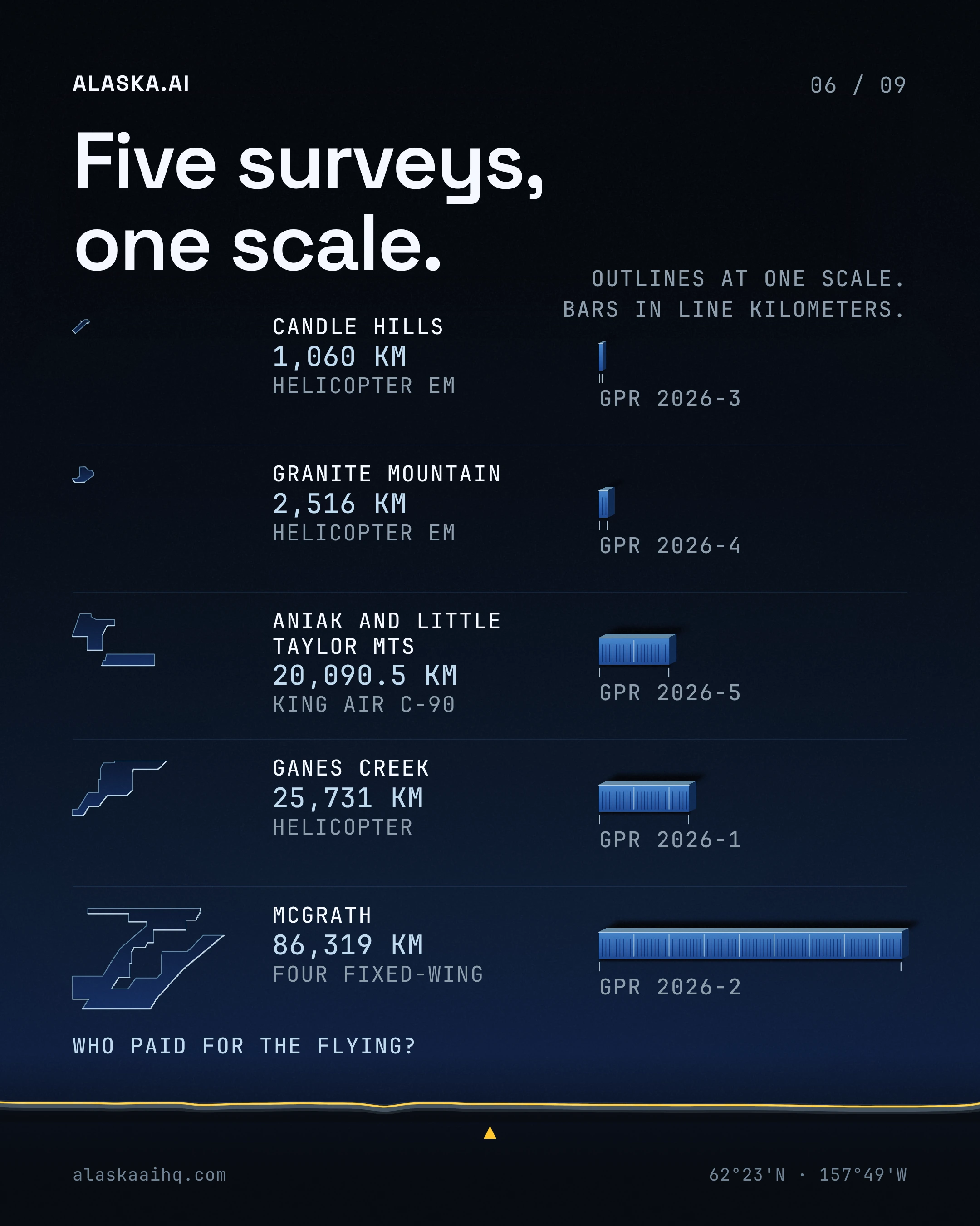
The Ganes Creek survey collected 25,731 line kilometers of airborne measurements.
The Ganes Creek survey covers part of the Kuskokwim Mountains west of McGrath.
The Ganes Creek survey area includes parts of the Ophir, Medfra, Iditarod and McGrath quadrangles.
EON Geosciences Inc. flew the Ganes Creek survey by helicopter from June 21st to September 7th, 2024.
Ganes Creek flying finished with a second helicopter season from June 16th to 25th, 2025.
DGGS published the Ganes Creek magnetic and radiometric survey as Geophysical Report 2026-1 in June.
The Ganes Creek survey was funded by USGS Earth MRI grants G22AC00475 and G23AC00408.
DGGS metadata bounds the Ganes Creek survey between latitudes 62.21 and 63.36 north and longitudes 154.27 and 158.42 west.
DGGS also published a separate McGrath airborne magnetic and radiometric survey as Geophysical Report 2026-2 in June.
The DGGS Aniak and Little Taylor Mountains survey covers 6,957 square kilometers, about 2,686 square miles.
DGGS accepted 20,090.5 line kilometers of data from the Aniak and Little Taylor Mountains survey.
The Aniak and Little Taylor Mountains survey was flown with flight lines 400 meters apart.
The Aniak and Little Taylor Mountains survey aircraft flew at a nominal 100 meters above the ground.
Terraquest Ltd. flew the Aniak and Little Taylor Mountains survey in a King Air C-90 between June 12th and November 8th, 2025.
Aircraft maintenance paused the Aniak survey from June 28th through September 9th, 2025.
The Aniak and Little Taylor Mountains survey covers parts of the Russian Mission, Sleetmute, Bethel and Taylor Mountains quadrangles of southwestern Alaska.
DGGS published the Aniak and Little Taylor Mountains survey as Geophysical Report 2026-5 in July.
The Aniak and Little Taylor Mountains survey was funded by USGS Earth MRI grants G23AC00408 and G24AC00629.
DGGS metadata bounds the Aniak and Little Taylor Mountains survey between latitudes 60.65 and 61.69 north and longitudes 156.69 and 160.10 west.
DGGS tags the Aniak survey with the Kuskokwim River, the Little Taylor Mountains and the village of Chuathbaluk among its keywords.
Both surveys collected magnetic data with cesium-vapour sensors and radiometric data with two gamma-ray spectrometers each.
DGGS says the Ganes Creek survey will improve understanding of the geology and mineral potential of the central Kuskokwim River region.
The USGS Earth Mapping Resources Initiative was launched in 2019.
Earth MRI is an initiative within the USGS Mineral Resources Program that maps geology to help find new critical mineral resources.
USGS says the Infrastructure Investment and Jobs Act invested in Earth MRI.
USGS says Earth MRI partners with state geological surveys, federal agencies, private industry, tribes and universities.
USGS calls Alaska a priority focus region for critical minerals with significant known or suspected potential.
The FAA proposed its rule for routine drone flights beyond visual line of sight on August 7th, 2025.
The proposed beyond visual line of sight rule carries RIN 2120-AL82 and would add a new Part 108 to Title 14.
The proposed rule says the FAA Reauthorization Act of 2024 directs its development.
As of October 22nd the Federal Register showed no final rule for normalizing drone flights beyond visual line of sight, only the 2025 proposal and two 2026 comment reopenings.
Executive Order 14307, signed June 6th, 2025, ordered a final beyond visual line of sight rule within 240 days.
UAF's drone program completed a 1,000 kilometer test flight carrying human blood samples for the International Testing Agency.
The test flight began and ended at Nenana Municipal Airport on August 19th.
The ACUASI flight lasted 8 hours and 47 minutes.
The Windracers ULTRA used in the test has a 200 pound cargo capacity.
The ULTRA has a 31 foot wingspan.
The ULTRA has a range of about 600 miles.
ACUASI owns two of the twin engine ULTRA aircraft.
The International Testing Agency's 2022 Doha trials used quadcopters over distances of up to 20 kilometers.
ACUASI Director Cathy Cahill said "If it's an emergency, you don't want to trust it to an amateur."
UAF says it runs one of nine FAA-designated unmanned aircraft systems test sites.
The DGGS McGrath airborne survey acquired 86,319 line kilometers of magnetic and radiometric data.
EON Geosciences flew the McGrath survey with four fixed wing aircraft from June 23rd to September 5th, 2024, and from June 14th to July 26th, 2025.
The McGrath survey was flown with lines 400 meters apart at a nominal 100 meters above the ground.
The McGrath survey covers parts of nine quadrangles, Norton Bay, Nulato, Ruby, Unalakleet, Ophir, Medfra, Holy Cross, Iditarod and McGrath.
The McGrath survey was funded by USGS Earth MRI grants G22AC00475 and G23AC00408.
DGGS says the McGrath survey data will promote resource exploration of the central Kuskokwim River region.
The Candle Hills airborne electromagnetic survey flew 1,060 line kilometers over a block of 369.5 square kilometers southwest of McGrath.
Geotech Ltd. flew the Candle Hills electromagnetic survey from August 5th to 12th, 2025.
The Granite Mountain airborne electromagnetic survey flew 2,516 line kilometers over a block of 916.5 square kilometers in the Iditarod Quadrangle.
Geotech Ltd. flew the Granite Mountain electromagnetic survey from August 12th to September 14th, 2025.
DGGS releases the Granite Mountain and Candle Hills electromagnetic data under an open end-user license.
DGGS calls the Iditarod Quadrangle a prime exploration target that includes historically productive mining districts.
The cover of DGGS Geophysical Report 2026-5 shows Terraquest's King Air C-90 grounded when the runway at Bethel's airport was closed by snow in a late-season storm.
DGGS provides the McGrath survey data under an open end-user license.
DGGS provides the Ganes Creek survey data under an open end-user license.
DGGS lists the fee for the McGrath, Ganes Creek and Aniak survey data as a free download.
The McGrath survey collected magnetic data with a Geometrics G-822A cesium-vapour sensor and radiometric data with two gamma-ray spectrometers.
DGGS published the Candle Hills airborne electromagnetic survey as Geophysical Report 2026-3.
DGGS published the Granite Mountain airborne electromagnetic survey as Geophysical Report 2026-4.
DGGS places the Candle Hills survey southwest of McGrath, across part of the Kuskokwim Mountains.
Geomorphic AI was founded early in 2026, according to North of 60 Mining News.
Geomorphic AI has not announced whether it has used Earth MRI datasets in its Alaska targeting work, according to North of 60 Mining News.
The two surveys together add more than 45,800 line kilometers of new geophysical data, according to North of 60 Mining News.
The two surveys together cover approximately 5,850 square miles of Southwest Alaska, according to North of 60 Mining News.
The executive order's 240 day target for a final drone rule fell on February 1st, 2026.
Transportation Secretary Sean Duffy announced roughly $249 million in federal funding for the Alaska Railroad to finish the stalled Port MacKenzie rail link.
The Port MacKenzie rail link the grant would finish is 32 miles long.
The Department of Energy opened about $38 million in grants for electric reliability and affordability in Alaska, according to Alaska's News Source.
The federal funding announcements for Alaska arrived as the midterm elections approached, according to the Anchorage Daily News.
Beats
This article is on Alaska land and permitting for AI · Defense and federal AI in Alaska · Alaska AI research and science. Each beat page keeps every decision and every article on that subject in one place.